As Kammuri moves away from the Marianas, Guam remains under a tropical storm warning, with gusty winds and wet weather expected to continue through the day.
The island remains in Condition of Readiness 2.
Although the storm made its closest point of approach at 2:30 a.m., damaging winds of up to 50 mph are possible throughout the day, according to the Joint Information Center. Winds should subside by the afternoon.
Seas will remain hazardous.
“Life-threatening rip currents will persist through early next week,” according to a JIC bulletin. “The community is reminded to avoid the ocean.”
A high surf warning is in effect for Guam, Rota, Tinian, and Saipan. Dangerous surf of 15 to 25 feet remains possible along north- and east-facing reefs.
Moderate to heavy rain is expected across the island throughout the day.
Schools are closed and Catholic masses have been suspended.
Local government offices, the University of Guam, Guam Community College and the District Court of Guam are also closed. They will reopen when the all-clear is given.
Military bases, however, remain operational. The military doesn’t enter COR 4 unless destructive winds of 54 mph are expected, as opposed to the civilian declaration, which occurs when damaging winds of 39 mph are expected.
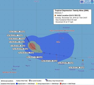
Gov. Lou Leon Guerrero has placed Guam in Condition of Readiness (COR) 3 at 11 a.m. today as Tropical Depression 29W could bring damaging winds of 39-57 mph within the next 48 hours.
The system is expected to pass south of Guam with the closest point of approach forecast around 4 a.m. Wednesday morning approximately 200 miles away from the territory.
Rainfall amounts of 4 to 5 inches is possible through Wednesday.
Tropical Depression 29W is being watched as it passes south of us. We can expect rain and wind on the tropical storm order over the next couple of days
A developing tropical depression will bring hazardous weather conditions to our region through Thanksgiving.
The National Weather Service has issued an advisory about the ongoing trade wind surge and a developing tropical depression that will combine to bring hazardous weather conditions to our region through Thanksgiving.
A statement from the weather service this morning warns that a strong ridge of high pressure over the North Pacific (the Trade Wind Surge) and a low-pressure system over eastern Micronesia (Invest Area 94W) have come together to produce a tighter pressure gradient over the Pacific east of the Marianas.
What that means is that the strong winds that have been blowing over the Marianas for the past few days will continue to increase in strength in the days ahead.
“We expect this wind surge to continue at least through Thursday,” states the NWS release.
Developing Tropical Disturbance to pass south of Guam
In addition to the trade wind surge, a low-pressure system in eastern Micronesia has been identified as is Invest Area 94W.
The NWS says they’ve been watching this circulation for a while and expect it to continue toward the Marianas.
Gradual development is expected as it nears Guam. However, the current forecast calls for 94W to pass just south of Guam late Tuesday night or early Wednesday morning.
Intensity forecasts vary and the system has been developing slowly so far.
“We’ll know more over the next 24 hours as 94W evolves,” according to the NWS release.
Residents of Guam and the CNMI should expect strong and gusty winds to increase through Tuesday night as the disturbance passes.
Current Watches and Advisories for Guam, Rota, Tinian, Saipan
Gale Watch: Increased risk of frequent gusts of 34 to 47 knots, most likely Tuesday through early Wednesday morning.
Wind Advisory: 6 a.m. Tuesday to 6 p.m. Wednesday: 25 to 35 mph winds from the northeast on Tuesday shifting to the southeast Wednesday. Loose outdoor objects could be blown away. This includes canopies, tarps, and tents as they could be damaged or cause damage.
Hazardous Seas Watch: Increased risk of seas of 15 feet or greater, most likely Tuesday through early Wednesday morning.
High Surf Advisory: 10 to 14 feet along north and east reefs; surf could build to between 15 and 20 feet on Tuesday.
Wave Watch model indicates surf advisories in some locations could be upgraded to surf warnings if the surf height exceeds 15 feet.
Small Craft Advisory: 15 to 25-knot winds with gusts up to 35 knots today; 20 to 30 knots with gusts to 40 knots on Tuesday. Combined seas of 9 to 11 feet, building higher tonight and Tuesday, to near 20 feet by Tuesday night.


 goes into COR 2